Welcome to A People's Atlas of Nuclear Colorado
Navigating the Atlas
Using the buttons on the left, you may also browse the Atlas's artworks and scholarly essays, access geolocated material on a map, and learn more about contributors to the project.
If you would like to contribute materials to the Atlas, please reach out to the editors: Sarah Kanouse (s.kanouse at northeastern.edu) and Shiloh Krupar (srk34 at georgetown.edu).
Cover Image by Shanna Merola, "An Invisible Yet Highly Energetic Form of Light," from Nuclear Winter.
Atlas design by Byse.
Funded by grants from Georgetown University and Northeastern University. Initial release September 2021.
Essay
Global Positioning, Positioned: GPS at Home on Schriever Air Force Base
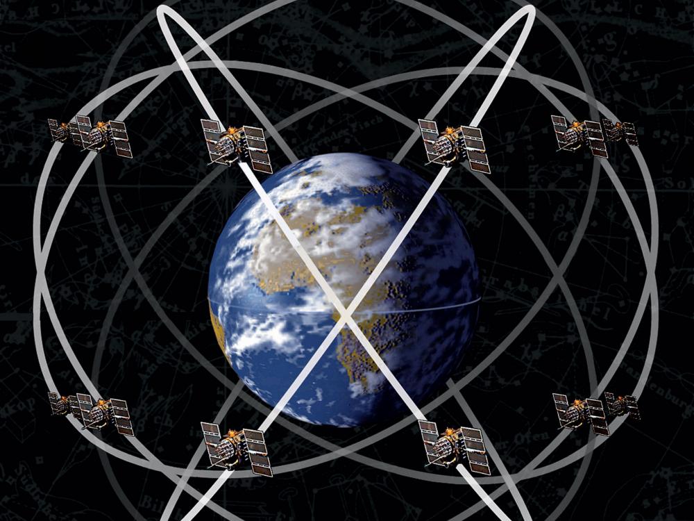
Visualization of Earth surrounded by global positioning navigation satellites, Smithsonian Institution
When we use a phone or car navigation to get directions, the Global Positioning System (GPS) seems automatic and its function, placeless. Depictions of the technology show a system that is apparently everywhere, an array of satellites circling the globe like an atomic cloud. A GPS receiver calculates position based on time, determined by deviations between highly accurate atomic clocks onboard. The difference in time between the receiver and at least four satellites can pinpoint a location within a few meters of accuracy. Yet, these calculations do not simply emerge from the air. The satellite array that makes GPS possible is built and maintained by the United States military. Schriever has been a crucial part of this infrastructure since the 1980s. See also: Lisa Parks, Cultures in Orbit: Satellites and the Televisual (Durham, NC: Duke University Press, 2005).Thinking about GPS as located at this base (though, of course, many other installations worldwide are part of its infrastructure) undoes this image of GPS as an ethereal calculation and instead reveals an earthbound system. GPS location is established not just by the satellite array, but also through the American military’s labor and Cold War history.
Amber Whittington, U.S. Air Force Thunderbirds fly over the radomes of the Colorado Tracking Station, part of the Air Force Satellite Control Network at Schriever Air Force Base. The image's original caption was: Air Power Meets Space Power, 30 May 2008, U.S. Air Force
Operated by the newly founded Space Force Division of the Department of the Air Force, Schriever is located east of Colorado Springs, on Colorado State Highway 94. It is beyond the local landfill, heading away from the mountains and toward the plains. Built in the 1980s and updated over the past few decades, the military installation is an unassuming set of buildings with a nearby subdivision housing personnel. Here, the domestic life and global operations of the Space Force Delta 8 combine. Even prior to the 2019 establishment of the Space Force, Schriever's emblem heralded, “Master of Space.” Staff Sgt. James Richardson, U.S. Space Force Public Affairs, "The U.S. Space Force Logo and Motto," United States Space Force website, July 22, 2020,
https://www.spaceforce.mil/News/Article/2282948/the-us-space-force-logo-and-motto/.The new logo and motto, Semper Supra, "always above," centers on the star Polaris, long known for its role in guidance. These images contrast with See, for example: Meryl Large and Actus Land Lease, "Tierra Vista Continues Progress in New Housing Area," Schriever Air Force Base website, March 10, 2009, https://www.schriever.spaceforce.mil/News/Article-Display/Article/278158/tierra-vista-continues-progress-in-new-housing-area/.materials promoting domestic life on base, a subdivision of military housing known as Tierra Vista at Schriever: rows of cookie cutter houses are set against the Rocky Mountains in the distance. A single main road connects the base and the subdivision.
Beyond the control gate and parking lot are two iconic bulbous white orbs. They are decommissioned remnants of the physical infrastructure of the Global Positioning System that was used in the 1980s, now an exhibition of "space power." Although many details of Schriever's operation are classified, the base is responsible for the operations and support of 185 Department of Defense satellites. The top-secret mission of monitoring these satellites is likely mostly mundane, albeit highly sensitive. The Gazette, "Super Secretive Defense Center near Colorado Springs Begins 24-hour Operations,” KKTV 11 News, February 19, 2018, http://www.kktv.com/content/news/Super-secretive-space-defense-center-near-Colorado-Springs-begins-24-hour-operations-474474833.html.Personnel in the region have jokingly referred to the base as Area 52. The Space Force command might be mistaken for a shopping mall or a prison in pictures, if the jet fighters overhead or the white orbs were absent. An all-powerful array of satellites is thus also part of a banal, suburban landscape. Schriever Space Force Base, "50th Space Wing - 65 Years of Mastering Space," https://www.schriever.spaceforce.mil/News/Article-Display/Article/735859/50th-space-wing-65-years-of-mastering-space/; "50th Space Wing," military-history.fandom.com, accessed January 13, 2023, https://military-history.fandom.com/wiki/50th_Space_Wing; U.S. Air Force, Schriever Air Force Base, "GPS at Schriever," accessed June 9, 2021, https://www.schriever.spaceforce.mil/GPS/.U.S. Air Force Fact Sheets describe the base as a 24/7 customer service center of excellence “supporting a wide variety of military, civilian, and commercial users and applications.” More than 8,000 military personnel and civilians are employed on the base to launch, maintain, and dismantle the satellite systems. U.S. Air Force, Schriever Air Force Base, "2nd Space Operations Squadron," July 2020 [last update], https://www.schriever.spaceforce.mil/About-Us/Fact-Sheets/Display/Article/275806/2nd-space-operations-squadron/.A mission control crew conducts 24-hour shifts to support the major functions of the GPS satellite constellation, including customer support. The Tierra Vista at Schriever Facebook page offers a record of domestic concerns: promoting a 4th of July BBQ, advocating for kitchen safety, and providing an online portal to pay rent.
Scott Prater, Tierra Vista subdivision, Schriever Air Force Base, 16 March 2010, U.S. Air Force
See also: Caren Kaplan, "Precision Targets: GPS and the Militarization of U.S. Consumer Identity," American Quarterly 58, no. 3 (2006): 693-713.Connections between domestic life, customer service, and global mastery repeat a familiar set of relations established during the Cold War. The project to build nuclear weapons, for example, was inextricable from the suburban nuclear family. The idea of dominating the globe by nuclear missiles was linked to domestic safety drills and the idea of a perpetual threat to the nation. Refer also to: Joseph Masco, The Theater of Operations: National Security Affect from the Cold War to the War on Terror (Durham, NC: Duke University Press, 2014); Shiloh Krupar, Hot Spotter's Report: Military Fables of Toxic Waste (Minneapolis, MN: University of Minnesota Press, 2013).These associations between global mastery and domestic life continue with GPS. Military uses of GPS include target tracking, missile and projectile guidance, search and rescue operations, reconnaissance and detection of nuclear detonation. At the same time, the system is a standard feature on our phones and has applications for fields as diverse as agriculture, mining, astronomy, and tectonics. Location-based mobile games like Pokémon Go rely on GPS—more than three million geocaching locations around the world are sought by players of the outdoor, treasure hunting game based on GPS coordinates.
American military satellites, first developed in the Cold War, did not have their origins in guidance or navigation. Rather, satellite infrastructure collected surveillance from space. The goal was to picture the entire globe in order to provide information for military missions and aerial targeting. It is easy to imagine these systems as part of the continuum of technologies that gives rise to today’s Google Maps. Yet, it is worthwhile to consider the difference between then and now; the difficulties of collecting early satellite images underline the role of labor and infrastructure. Early surveillance satellites used conventional cameras. Dino A. Brugioni, Eyes in the Sky: Eisenhower, the CIA, and Cold War Aerial Espionage (Annapolis, MD: Naval Institute Press, 2011).Film capsules attached to a parachute would be retrieved mid-air by helicopter and taken to an Air Force laboratory for processing. Needless to say, there was a significant time lapse between taking the picture and using it as military intelligence. Satellite images could become irrelevant by the time the surveillance reached military leaders.
Today’s GPS is also not without glitches. GPS signals can be blocked by mountains, tall buildings, and atmospheric conditions. The radio signals sent by satellite can also be easily jammed, and a number of illegal systems are widely available to disrupt GPS transmissions. Kashmir Hill, "Jamming GPS Signals is Illegal, Dangerous, Cheap, and Easy," Gizmodo, July 24, 2017, https://gizmodo.com/jamming-gps-signals-is-illegal-dangerous-cheap-and-e-1796778955.The most common use is by truckers who seek to evade detection and tracking by GPS. Militaries and spy agencies also use jamming technologies; in Mosul, after commercially available drones were used by the Islamic State to drop hand grenades, the GPS-guided aircraft were rendered useless by what Iraqi forces called a Richard Sisk, "US ‘Jammer’ Curbs ISIS Drone Threat in Mosul Battle," Military.com, March 8, 2017, https://www.military.com/defensetech/2017/03/08/jammer-curbs-isis-drone-threat-mosul.“parasite-machine,” an American device used to jam the GPS signals to the drones. Even a publicity picture of a 2017 visit by Vice President Mike Pence to Schriever Air Force Base was deemed to be a possible security threat, potentially revealing hidden details of the Air Force’s space operations. Jamie McIntyre, "The Air Force’s PR Fiasco: How a Plan to Tighten Security Backfired," Washington Examiner, March 14, 2018, https://www.washingtonexaminer.com/policy/defense-national-security/the-air-forces-pr-fiasco-how-a-plan-to-tighten-security-backfired.This led the Air Force to suspend all base visits.
Emblem of the 50th Space Squadron, headquartered at Schiever Air Force Base, 1992, U.S. Air Force
Schriever, moreover, is not uniformly held up as an emblem of "space power." In 2017, activists held a vigil outside the base as a part of a campaign against the militarization of space. At the action, two nuns presented a copy of the new United Nations’ Treaty on the Prohibition of Nuclear Weapons. Debbie Kelley, "Anti-War Nuns to Bring Message of Nuclear Disarmament," U.S. News & World Report, October 7, 2017, https://www.usnews.com/news/best-states/colorado/articles/2017-10-07/anti-war-nuns-to-bring-message-of-nuclear-disarmament; Global Network Against Weapons and Nuclear Power in Space, "International Week of Protest to Stop the Militarization of Space [7-14 October]," DiaNuke.org, September 22, 2017, http://www.dianuke.org/international-week-protest-stop-militarization-space-7-14-october/.Their action emphasized the overlay between nuclear systems and contemporary targeted killing by drone, two scales of military strikes that are both monitored by satellites. The protest is a reminder of how, despite the end of the Cold War, the infrastructure of global domination and permanent threat has remained. In the war on terror, the logics have shifted to an expansive theater of war fought by personnel in the United States who bomb and kill targets abroad through the use of satellite links.
Domination and control is the basis for Air Force Space Command and the constellation of satellites that they operate from Schriever Air Force Base. Yet, the ordinary landscape of the Eastern Colorado plains, a 24-hour work cycle, highway traffic, and suburban housing developments are all inextricably linked to this project. In a meeting with the Colorado Springs Chamber of Commerce in 2018, the Air Force outlined its concerns with traffic, which was linked to the growth of the base. Local headlines announced, Tom Roeder, "Air Force Space Command Boss has Earth-bound Problem: Colorado 94," The Gazette, May 1, 2018, https://www.coloradopolitics.com/news/air-force-space-command-boss-has-earth-bound-problem-colorado-94/article_fca87b4e-e20e-5430-a0c3-dba0da9c6828.html.“Air Force Space Command boss has Earth-bound problem: Colorado 94.” An earthbound understanding of GPS might locate these as part of its position, troubling the vision of mastery that the technology proposes.
Sources
Brugioni, Dino A. Eyes in the Sky: Eisenhower, the CIA, and Cold War Aerial Espionage (Annapolis, MD: Naval Institute Press, 2010).
Global Network Against Weapons and Nuclear Power in Space. “International Week of Protest to Stop the Militarization of Space [7-14 October].” DiaNuke.org, September 22, 2017. Accessed July 17, 2020.
Hill, Kashmir. “Jamming GPS Signals is Illegal, Dangerous, Cheap, and Easy.” Gizmodo, July 24, 2017. Accessed July 17, 2020.
Kaplan, Caren. "Precision Targets: GPS and the Militarization of U.S. Consumer Identity." American Quarterly 58, no. 3 (2006): 693-713.
Kelley, Debbie. “Anti-War Nuns to Bring Message of Nuclear Disarmament.” U.S. News & World Report, October 7, 2017. Accessed July 17, 2020.
Krupar, Shiloh. Hot Spotter's Report: Military Fables of Toxic Waste. Minneapolis, MN: University of Minnesota Press, 2013.
Large, Meryl and Actus Land Lease. “Tierra Vista Continues Progress in New Housing Area.” Schriever Air Force Base website, March 10, 2009. Accessed January 13, 2023.
Masco, Joseph. The Theater of Operations: National Security Affect from the Cold War to the War on Terror. Durham, NC: Duke University Press, 2014.
McIntyre, Jamie. “The Air Force’s PR Fiasco: How a Plan to Tighten Security Backfired.” Washington Examiner, March 14, 2018. Accessed July 17, 2020.
Parks, Lisa. Cultures in Orbit: Satellites and the Televisual. Durham, NC: Duke University Press, 2005.
Roeder, Tom. “Air Force Space Command Boss has Earth-bound Problem: Colorado 94.” The Gazette, May 1, 2018. Accessed July 17, 2020.
Saunders, Randy, Schriever Space Force Base. “50th Space Wing - 65 Years Mastering Space.” Accessed January 13, 2023.
Sisk, Richard. “US ‘Jammer’ Curbs ISIS Drone Threat in Mosul Battle.” Military.com, March 8, 2017. Accessed July 17, 2020.
The Gazette. “Super Secretive Defense Center near Colorado Springs Begins 24-hour Operations.” KKTV 11 News. February 19, 2018. Accessed July 17, 2020.
U.S. Air Force, Schriever Air Force Base. “2nd Space Operations Squadron.” July 2020 [last update]. Accessed January 13, 2023.
U.S. Air Force, Schriever Air Force Base. "GPS at Schriever." Accessed January 13, 2023.
U.S. Space Force. "About the United States Space Force." Accessed May 10, 2021.